
Project snapshot
| Item | Evidence-led position |
|---|---|
| Project | Irwell River Park Connectivity and Movement Strategy |
| City | Salford |
| Corridor | River Irwell corridor from Salford Quays toward the city centre and Peel Park |
| Approximate extent | 8km stretch referenced in Salford and Greater Manchester reporting |
| Public sponsor | Salford City Council |
| Design / consultant team | Re-form Landscape Architecture, with Civic Engineers, Counter Context and Ashton Hale referenced in local reporting |
| Planning status | Approved by Salford City Council in April 2025 as a material planning consideration |
| Main purpose | Movement, connectivity, public realm, active travel and river-corridor identity |
| Character areas | The Meadows, Anaconda, Salford City, Ordsall Riverside and Salford Quays are identified in reporting |
| Funding position | Strategy itself has no direct council financial implication; it supports developer discussions and future funding opportunities |
| Investor reading | Useful place-quality signal, but benefits depend on funded delivery, developer obligations and maintenance |
Location and strategic context
The River Irwell is one of the defining urban edges between Manchester and Salford. For decades it has carried a complicated legacy: industrial history, flood risk, traffic severance, water-quality problems, underused riverside land and occasional high-quality waterfront interventions that do not always join up into a continuous experience.
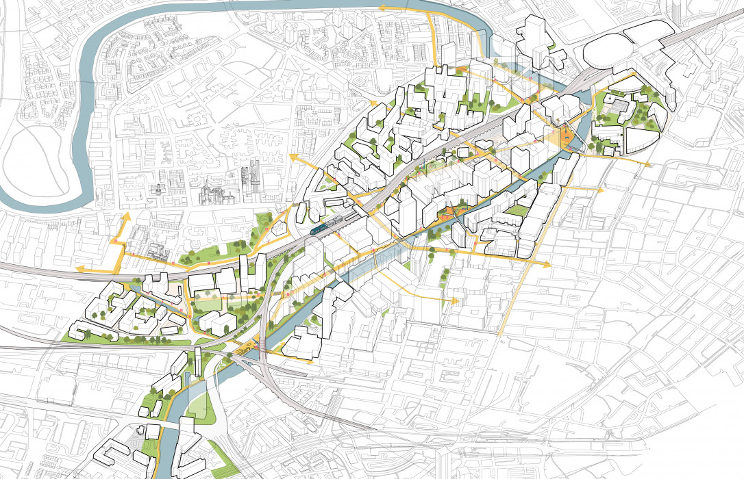
Irwell River Park is designed to repair that fragmentation. The strategy is focused on creating a continuous, legible and safer riverside route between major destinations: Salford Quays, Ordsall, the city centre, New Bailey, Chapel Street, the University of Salford and Peel Park. Its regeneration value comes from joining places together rather than replacing one site with one large new development.
What is proposed or delivered
The approved strategy seeks to guide future development and investment so that the Irwell becomes a connected urban park. Salford and Greater Manchester reporting describe ambitions for:
- uninterrupted, attractive and safe walking/cycling routes near the river;
- better access from local neighbourhoods and public transport;
- public spaces and parks that support people and nature;
- climate resilience, including sustainable drainage and flood-mitigation thinking;
- improved lighting, wayfinding, safety and identity;
- better links through narrow riverside sections, especially Ordsall Riverside;
- a landmark waterfront experience at Salford Quays.
The project should be understood as a planning and movement framework. Some individual improvements may be delivered through public funding, but many are likely to be secured through planning conditions, section 106 obligations, design guidance, developer-led public realm and future funding bids.
Partners, public bodies and funding
Salford City Council is the lead public body. Place North West reports that landscape architect Re-form designed the project, with Civic Engineers, Counter Context and Ashton Hale also working on it.
The council decision record says the strategy will be used alongside the local plan to facilitate discussions with developers, identify opportunities to improve connectivity and support funding opportunities. It also states that the strategy itself had no direct financial implications for the council.
That distinction matters. The approval gives the council a stronger planning and negotiation tool, but it is not the same as a fully funded capital programme for the entire 8km corridor. Delivery will depend on future projects, developer contributions, council priorities, transport/public-realm funding and long-term maintenance.
Planning and governance status
The April 2025 cabinet decision approved the Irwell River Park Connectivity and Movement Strategy and requested that it be treated as a material planning consideration. The decision record says that once finalised, it would not become an adopted Development Plan Document, but would still be material when considering planning applications.
The decision followed consultation in late 2024. Salford CVS described the consultation as a refresh because previous planning guidance was over 15 years old, outdated and no longer adopted by Salford. Open Council's decision record also notes that Irwell City Park Planning Guidance was revoked by Salford in January 2024, creating the need for further work to support implementation.
Character areas
| Area | Strategic role |
|---|---|
| The Meadows | Green and ecologically rich area where access, safety and natural beauty are key themes |
| Anaconda | Flood/river-edge landscape context, often discussed alongside the Meadows in public summaries |
| Salford City | Urban riverside zone where continuous pathways and links to key destinations are central |
| Ordsall Riverside | Narrower riverside paths where widening, lighting and safer pedestrian/cycle movement are priorities |
| Salford Quays | Landmark waterfront destination where people and nature can be brought closer together |
Timeline
| Date / period | Milestone |
|---|---|
| 2008 | Earlier Irwell City Park guidance developed by Salford, Manchester and Trafford partners |
| January 2024 | Salford revokes the older Irwell City Park Planning Guidance |
| Autumn 2024 | Public consultation on a refreshed Irwell River Park strategy |
| April 2025 | Salford City Council approves the Irwell River Park Connectivity and Movement Strategy |
| April 2025 onward | Strategy becomes a material planning consideration and a tool for developer/funding discussions |
| Next decade | Council ambition is for the area to become a greener, healthier and more connected part of daily life in Salford |
Property investor section
For investors, Irwell River Park is best understood as a place-quality overlay across several submarkets rather than a scheme that creates one immediate uplift event. It affects how to read waterside and near-waterside assets in Salford Quays, Ordsall, New Bailey, Chapel Street and around Peel Park.
The positive signal is that Salford now has a clearer planning framework for requiring or negotiating better riverside access, public realm, active-travel routes and green infrastructure. Over time, that can make individual sites more connected, legible and attractive to residents, workers and visitors.
The caution is that strategy does not equal delivery. Investors should check whether a specific building actually benefits from completed routes, safe lighting, maintained landscaping, flood-risk management, water-quality improvements and genuine connections to tram, rail, bus and employment nodes. Rental impact is qualitative and should not be read as a price or rent forecast.
The strongest due-diligence question is: does the asset already sit on a useful, safe and well-managed movement corridor, or is it relying on future Irwell River Park interventions that are not yet funded or delivered?
Risks and watch points
- Funding: the strategy itself is not a fully funded capital programme.
- Delivery by others: many improvements may rely on developers, planning obligations and phased schemes.
- Maintenance: riverside routes need lighting, cleaning, landscape care and safety management.
- Water quality: River Irwell pollution and sewage-spill concerns can affect public perception and ecological outcomes.
- Flood risk: river-corridor improvements must work with flood management, not against it.
- Severance: roads, private land, level changes and narrow paths can make continuous riverside access difficult.
- Inclusivity: public spaces need to feel safe and usable for all groups, not only commuters or new development residents.