
Project Overview
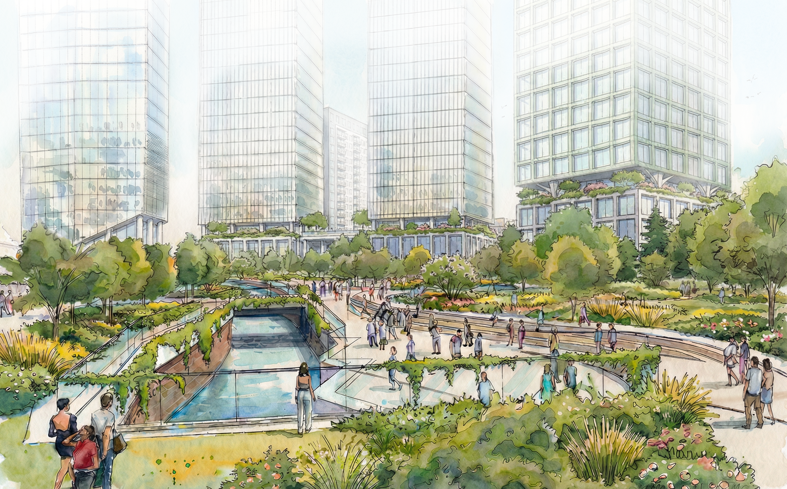
The Water Street Strategic Regeneration Framework is a spatial and planning framework prepared for Manchester City Council. Its role is to guide future planning applications and investment rather than to grant detailed permission for a single project. The council’s consultation page states that the updated 2026 SRF proposes a new neighbourhood with mostly homes, a large park along the River Medlock, better walking and cycling routes, new uses for the viaduct arches, and stronger links to surrounding districts. The draft SRF itself is described in official search records as a spatial framework that will help guide future planning applications, support public consultation, and inform coordinated development. 3
The 2026 update is more focused than the wider historic Water Street regeneration area. Official search records for the draft SRF say the update concentrates on the remaining undeveloped land between Water Street and the River Medlock. That matters because some surrounding plots have already been developed or are under construction, while the updated framework is aimed at the land that still needs a coordinated vision. The council’s city-centre regeneration page also includes an interactive map placing Water Street within the west side of central Manchester. 4
| Key data | Current position | Source |
|---|---|---|
| Lead authority | Manchester City Council | 5 |
| Project type | Strategic regeneration framework guiding residential-led mixed-use regeneration | 6 |
| Geography | Wider Water Street area sits between St John’s, Castlefield, the A57 and the River Irwell; 2026 update focuses on remaining undeveloped land between Water Street and the River Medlock | 7 |
| Current status on 6 July 2026 | Draft SRF endorsed in principle for consultation; consultation closed; final executive sign-off reported as expected on 8 July but not yet confirmed in official sources reviewed | 8 |
| Homes | Officially described as “hundreds”; no final public dwelling total identified in reviewed council material | 9 |
| Earlier confirmed estimate | The 2017 SRF envisaged 800 to 900 new homes | 10 |
| Towers | Council materials refer to taller buildings at the site edge; trade media report a four-tower concept, but this is not yet confirmed in adopted council material | 11 |
| Affordable housing | Official ambition for affordable homes to be strongly represented | 12 |
| Park | New urban park along the River Medlock, potentially similar in size to Mayfield Park | 13 |
| Adjacent schemes | Potato Wharf completed nearby; Vista River Gardens / Trinity Islands under construction, 1,950 homes across four towers of 39 to 60 storeys | 14 |
| Site size | Trade press reports a 4.4-acre Manchester Industrial Centre parcel within the framework area; this figure is media-reported, not a reviewed council confirmation for the whole SRF area | 15 |
| Column 1 |
|---|
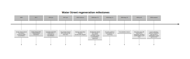
The earlier milestones come from Manchester City Council’s 2017 Executive report, which states that previous frameworks were endorsed in 2007 and 2011, that a refreshed draft SRF was endorsed in principle on 27 July 2016, and that the final Water Street SRF was then endorsed on 11 January 2017. The 2026 milestones come from the council’s consultation and news pages and from local trade reporting on the expected next Executive decision. 16
Location and Context
Water Street occupies a strategically awkward but potentially valuable piece of Manchester city centre. The council describes the wider area as sitting between St John’s, Castlefield, the A57 and the River Irwell. The refreshed 2026 publicity narrows attention to land bound by Trinity Way and the River Medlock. Together, those references place Water Street on the western and south-western edge of the centre, where the city’s historic canal and viaduct fabric meets inner-ring-road infrastructure and newer high-rise growth. 17
Current conditions are part of the rationale for intervention. Manchester City Council says the area is characterised by low-rise industrial warehousing, cleared land and development compounds, while council publicity in May 2026 describes it as one of the city centre’s last significant regeneration opportunities. That underused condition sits beside places that are already more legible and established: Castlefield to the east and south-east, St John’s to the north-east, and the Trinity Islands–New Jackson corridor to the south. 18
Background to the Regeneration Framework
Water Street has a long planning history. The 2017 Executive report says the 2016 SRF was the third framework for the area, following earlier documents endorsed in 2007 and 2011. It also records that an SRF was endorsed by the Executive in June 2011 and that the July 2016 draft was refreshed to reflect changes in Manchester’s economic priorities, market conditions and regeneration context. In January 2017 the Executive endorsed the final framework and asked Planning and Highways Committee to treat it as a material consideration in future applications. 10
The 2026 update is therefore not a new idea from scratch; it is a recalibration. Official 2026 council statements say the previous strategic framework was first agreed in 2017 and that the new draft significantly increases ambition. Council search records summarise that shift as a move towards a residential- and landscape-led strategy centred on a major new park. 19
That refresh also reflects what has changed around the site. The council’s city-centre regeneration page says Potato Wharf has been completed nearby and that construction began on Vista River Gardens on the Trinity Island site in autumn 2022. The same page notes that Vista River Gardens is planned as 1,950 homes across four towers of 39 to 60 storeys, with the first two towers due in 2026. In other words, Water Street is being reconsidered in a context where neighbouring regeneration has accelerated and the west side of the centre is no longer peripheral in planning terms. 14
Vision and Objectives
The official vision is plainly residential-led, but it is also strongly public-realm-led. The consultation page, council news releases and search records all foreground the same package: mostly homes, affordable housing, a large Medlock-side park, better active-travel connections, revived arches, and stronger links to neighbouring districts. Official wording also stresses that the site should become a coherent neighbourhood rather than a set of unrelated plots. 20
The most important qualitative shift from the earlier framework is that landscape now appears to be the organising device rather than a supporting amenity. Manchester City Council says the park would follow the River Medlock, be flexible, inclusive and climate resilient, and be framed by taller buildings that shield it from the inner ring road. That suggests a deliberate attempt to use built form and open space together: density at the edges, calm public space within. 12
Proposed Housing and Land Uses
Official council material stops short of publishing a final dwelling total for the 2026 update. The public wording is “hundreds of new homes”, with affordable homes “strongly represented” and active ground-floor uses for retail, hospitality, leisure and community amenities. That is the most reliable current position for publication because it comes directly from Manchester City Council. 9
For historical comparison, the 2017 Executive report stated that the framework would see the delivery of 800 to 900 new homes, while trade reporting on the 2026 refresh says the earlier preferred option for the council-owned Manchester Industrial Centre involved about 900 homes across five blocks, the tallest rising to 31 storeys. Place North West and Housing Today both report that the 2026 concept has become taller and denser, with a four-tower concept under discussion; Housing Today also described the refreshed scheme as one that could contain “thousands” of homes. Those latter figures should be treated as indicative media descriptions rather than confirmed council numbers. 21
The land-use mix is clearer than the quantum. Public council sources refer repeatedly to small-scale retail, hospitality, leisure, community amenities and new uses for viaduct arches. That implies a neighbourhood intended to operate at street level and through the day, not simply a residential enclave. Whether that mixed-use ambition survives viability testing and later plot-by-plot applications will be one of the key delivery tests. 22
Place, Public Realm and Planning
Public Realm and Green Space
The proposed park is the defining feature of the 2026 update. Manchester City Council says it would sit along the River Medlock and may be similar in size to Mayfield Park. Mayfield Park itself is officially described by the council as 6.5 acres, so the comparison signals a materially significant city-centre open space rather than a token landscape strip. 13
That comparison is important because Mayfield has already become Manchester’s most prominent example of park-led city-centre regeneration. The Water Street concept borrows some of the same language: green-blue infrastructure, Medlock frontage, climate resilience, and a public space large enough to shape the identity of the area around it. The crucial unknown is not whether a park is proposed, but how much of it is genuinely public, how early it would be delivered, and how it would be maintained. Those details are not yet spelled out in the publicly reviewed material. 23
Transport, Walking and Cycling Connections
The framework’s movement strategy is one of repair. Council materials describe the area as fragmented and disconnected, and say the refresh is intended to repair long-severed links through the neighbourhood. Better walking and cycling routes are central to the pitch, with the consultation page explicitly listing them as a headline component of the draft plan. 24
The most distinctive transport idea in the public material is an elevated green route to Deansgate-Castlefield tram stop via the Bridgewater Viaduct. That proposal is not yet a committed scheme, but it shows how the council is thinking about reusing infrastructure rather than merely building around it. In planning terms, Water Street’s success will depend less on road access than on whether it can be knitted into surrounding pedestrian, cycle and tram networks. 12
Heritage and Character
The framework is not positioned as a clean-slate redevelopment. Manchester City Council says the plans will celebrate the area’s industrial character and waterways, while May 2026 publicity refers specifically to the “heritage arch ways” that characterise the site. The viaducts and arches therefore function in the public narrative as assets to be activated rather than obstacles to be erased. 9
This matters because Water Street sits immediately beside Castlefield’s heritage context and alongside St John’s cultural regeneration. The 2017 Executive report also framed the area as benefiting from links to the Museum of Science and Industry and neighbouring investment at St John’s. What is still missing from the public evidence base is a detailed heritage or townscape assessment for the 2026 concept. That makes later planning applications especially important, because building heights, podium treatment, sunlight, views and viaduct reuse will all need to be tested in far greater detail. 25
Planning and Consultation Status
The clearest confirmed planning milestone is 13 March 2026. Manchester City Council’s consultation page says that on that date the Executive approved the draft SRF in principle and authorised a public consultation exercise. Executive minutes indexed by the council confirm that the draft SRF update was endorsed in principle as a basis for consultation. 26
By 15 May 2026 the council said consultation was underway, and the consultation page states that comments had to be received by Monday 25 May 2026. The official sources reviewed publicly display the draft SRF and the closed consultation page, but not a final adopted SRF. Local trade coverage published on 2 July reported that more than 90 per cent of respondents supported the key principles and that Executive sign-off was expected on 8 July. Until the Executive agenda, report or minutes are published, that level of support should be treated as media-reported rather than officially verified in the sources reviewed here. 27
Delivery and Phasing
The council has already indicated the likely next delivery mechanism. Its March 2026 news release states that once a final version of the SRF is approved, the council will initiate a marketing exercise to engage potential development partners for the land it controls. That implies at least part of the area is expected to proceed through a public-sector-led land and partner strategy rather than a single pre-assembled private development. 28
Because the framework is strategic rather than plot-specific, delivery is very likely to be phased. Future planning applications, legal agreements, infrastructure design and land assembly will determine sequence and pace. The council’s planning register is the formal route for monitoring those future applications. For now, no plot-by-plot planning package tied to the 2026 SRF appears in the reviewed official public material, which reinforces that Water Street is still at framework stage. 29
Strategic Implications
Potential Benefits
If delivered well, Water Street could achieve several public-policy goals at once. It would bring underused central land into productive use, add housing close to jobs and public transport, create a substantial new city-centre open space, improve walking and cycling links, and help knit together several neighbouring districts that currently read as separate fragments. Those are not speculative benefits invented after the fact; they are the explicit aims of the framework as described by the council. 20
The strongest public benefit case lies in the combination of housing with landscape and connectivity. The framework does not simply propose more residential floorspace; it attempts to make the Medlock corridor a usable public setting and to use viaducts, arches and new routes to make the west side of the centre more permeable. In a city-centre context where green space is scarce, that combination is potentially significant. 30
Key Challenges and Risks
The principal risk is that the public ambition remains more precise than the delivery detail. The council has not yet published, in the reviewed sources, a final housing total, affordable-housing percentage, delivery phasing plan, or formal building-height schedule for the 2026 update. That leaves important questions unresolved: how much density is proposed, how much of it is affordable, when the park appears, and how public-realm delivery is secured against viability pressure. 31
There are also clear place-making risks. The site is constrained by ring-road infrastructure, viaducts, waterways and surrounding tall-build context. Trade press reports suggest a denser, taller concept than before; if that is confirmed in due course, design quality, sunlight, wind, servicing and townscape impacts will become critical. In short, Water Street’s opportunity is large, but so is the penalty for getting density, phasing or public space wrong. 32
Relationship with Wider Manchester Regeneration
Water Street should be read as part of a broader western-city-centre arc rather than as a stand-alone scheme. To the north-east sits St John’s, whose 2016 SRF update described the area as having capacity for 2,500 new homes as part of a wider cultural and mixed-use transformation. To the south lies New Jackson, which the council says will deliver more than 6,300 homes. Immediately adjacent, Trinity Islands / Vista River Gardens is a 1,950-home cluster under construction. 33
That context matters analytically in two ways. First, Water Street is one of the missing connective pieces between these districts. Second, it is entering a market and planning geography already shaped by very large nearby residential schemes. The framework’s distinctiveness therefore depends less on sheer density than on its public park, Medlock frontage and viaduct-led connections. 34
Property Market and Investor Considerations
For the property market, Water Street is significant because it sits between established city-centre destinations and emerging residential clusters. Castlefield, St John’s, Trinity Islands and New Jackson already create a strong western and south-western residential geography, and the council’s own figures for nearby schemes show the scale of supply being delivered around the site. In that context, Water Street could become an important link in Manchester’s west-side living market if the park and connectivity proposals are translated into real place quality. 35
For investors, however, caution is essential. The 2026 framework does not yet confirm exact dwelling numbers, tenure mix, height schedule, phasing, service-charge implications or estate-management arrangements. Nor is final Executive adoption confirmed in the official sources reviewed as of 6 July 2026. The investment case therefore rests on location and future amenity potential rather than on a settled development proposition. The key variables to watch are straightforward: formal adoption, developer selection, when the park is delivered, what share of homes are affordable, and whether the neighbourhood emerges as genuinely mixed-use rather than as a narrow apartment cluster. 36
Social and Environmental Considerations
Community and Social Impact
The social promise of Water Street lies in its combination of housing and open space. Official materials repeatedly refer to affordable homes being strongly represented and to an inclusive public park designed for broad use. If that ambition is carried into the eventual planning applications, the framework could help address two persistent city-centre issues at once: limited access to genuinely public green space and the need for a broader tenure mix in central Manchester. 12
The caveat is that these are still framework-level intentions. The reviewed public sources do not yet provide an affordable-housing schedule, family-housing commitment, social-infrastructure plan or section 106 package tied to the update. For residents and civic stakeholders, the question is not whether the rhetoric is there, but whether later applications make the public and social commitments measurable. 37
Environmental and Climate Considerations
Environmental themes are unusually prominent in the public material. The council says the park would be climate resilient and aligned with the Medlock river corridor, while the emphasis on walking, cycling and viaduct reuse suggests a lower-car, connectivity-led neighbourhood model. Mayfield is an obvious local benchmark here too: the council’s own case study highlights how a Medlock-side park can combine landscape, habitat and public access. 38
What is still missing is the technical evidence base. The reviewed public sources do not yet expose detailed flood-risk work, drainage strategy, biodiversity net-gain proposals, energy strategy or whole-life carbon assessments for the new Water Street concept. Those documents usually arrive with later planning submissions, and they will be essential for judging how far the current climate language translates into enforceable project performance. 37
Next Steps
What to Watch Next
The immediate next milestone is whether Manchester City Council formally approves the final 2026 SRF, which local trade coverage said was expected on 8 July 2026. After that, the most important signals will be the publication of a final adopted SRF, any council land-marketing exercise, selection of development partners, and the first plot-specific planning applications. Only at that point should readers expect firm answers on heights, dwelling totals, affordable-housing mix, park delivery sequence and legal obligations. 39
Data gaps and documents to obtain
The current public evidence base is sufficient to understand the strategic direction, but not yet the full delivery proposition. The most useful additional documents to obtain are the final adopted SRF if and when approved, the Executive report on consultation results, any July 2026 Executive minutes, land-ownership and red-line plans, plot-level design and access statements, viability and affordable-housing appraisals, transport and active-travel drawings, flood and drainage studies, and any future section 106 heads of terms. The reviewed official pages publicly expose the draft SRF, consultation material and general planning register, but not that fuller delivery pack. 40
Conclusion
Water Street is one of Manchester’s more consequential current framework-led regeneration sites because it is trying to do more than intensify a leftover parcel. The council’s 2026 update aims to turn a severed western edge of the city centre into a connected residential neighbourhood organised around a Medlock-side park, active ground floors and reused viaduct infrastructure. In policy terms, that is an ambitious and attractive proposition. 24
But Water Street remains a strategic framework with significant unresolved variables. The ambition is visible; the delivery detail is not yet settled. The project’s eventual importance will therefore depend on whether the promised public benefits, especially the park, connectivity and affordable housing, are secured early and credibly enough to shape the neighbourhood from the outset rather than being deferred behind private development. 41
1 3 5 6 20 26 31 36 37 40 41 Water Street consultation | Manchester City Council
https://www.manchester.gov.uk/consultations-and-surveys/water-street-consultation
2 7 14 17 34 Water Street | City centre regeneration areas | Manchester City Council
4 Water Street Strategic Regeneration Framework Update
8 Executive Minutes of the meeting held on Friday, 13 March 2026
9 11 19 22 27 New Image: Consultation underway for Manchester’s newest neighbourhood | Manchester City Council
10 16 21 25 Microsoft Word - 21 Water Street SRF.doc
https://democracy.manchester.gov.uk/Data/Executive/20170111/Agenda/21_Water_Street_SRF.pdf
12 13 18 23 24 28 30 38 Water Street: One of the final pieces of the central Manchester regeneration jigsaw set to be transformed | Manchester City Council
15 Manchester pushes Water Street SRF forward
https://www.placenorthwest.co.uk/manchester-pushes-water-street-srf-forward/
29 See or comment on planning applications
32 Manchester looks to finish Water Street regen zone with ...
33 St John's Strategic Regeneration Framework Update
https://www.manchester.gov.uk/__data/assets/file/0021/160077/st_johns_srf_-_november_2016.pdf
35 New Jackson Street | City centre regeneration areas
39 Public backs Water Street regeneration with new city centre ...